Learn how the landscape was shaped in Grange Moor.
Starting in Grange Moor, you are stood on the Birstall Rock, which is a thick sandstone. See if you can detect the tranistion from this resilient sandstone to the underlying mudstone as you begin to descend down the hillside, and again later on in the walk, when you ascend back up to the Birstall Rock.
Have a quick look at the Dumb Steeple. Notice that some of the bricks are narrow and containcross bedding, this is local stone, which contrasts with the much pinker stone that has been imported probably from near Doncaster to make more recent repairs.
As you leave Grange Moor you will see a spectacular view to the North and the East. The hill you stand on is important as it demarks the watershed between the Calder River catchment and the Dearn River catchment. To the Southeast of here rainwater will enter the River Dearn basin, and be transport to the River Ouse via the Don. Rain that falls to the North and to the East of the village will run off into the Calder. This will also eventually find itself in the River Ouse, but by way of the River Air in North Yorkshire. Thus the dividing line here between rainwater catchments determines quite a different journey for water to the North Sea.
The firstexposureyou will find is in Briestfield Beck. As you cross the river you can see rock exposed on both sides of the bridge through the erosional action of the river. The rock here is a very fine grained, hard grey-blue material, which suggests it is a mudstone that was deposited in slow moving waters of a lake or a lagoon between ancient river channels.
You can also see the bright orange colouration of miningleachateflowing into the river, and what appears to be coal spoils from local mining activity, on both sides of the river.
You will eventually come to another rock exposure as you walk down Fixby Lane. You can see some thickflaggysandstone beds behind the gates of a cottage that become thinner higher up the sequence. These are the Falhouse Rocks, and were laid down in a river channel within a huge regional delta. The thickerbedding planesrepresent deposition from a high energy current in a river, bringing in lots of material during a given time. The narrower horizons of thinsiltsonerepresent deposition from the margins of the river channel, where less material is in suspension, and the water moves more slowly. This contrast indepositional environmentmeans the river had changed position (known asavulsion).
You can see some relic indicators of this river system; notice thecross beddingthat runs discordant to the bedding planes. This is a result of a current moving sand from the shallow slope of a small ripple to the steeper side. This asymmetry can tell us the direction of river flow from 310 million years ago!
You can have a closer look at these rocks just around the corner as you turn off Fixby Lane onto the farm track. You might also notice that these rocks aredippingin a slightly different orientation to the rocks across the road, which suggests there has been some localised faulting or landslips.
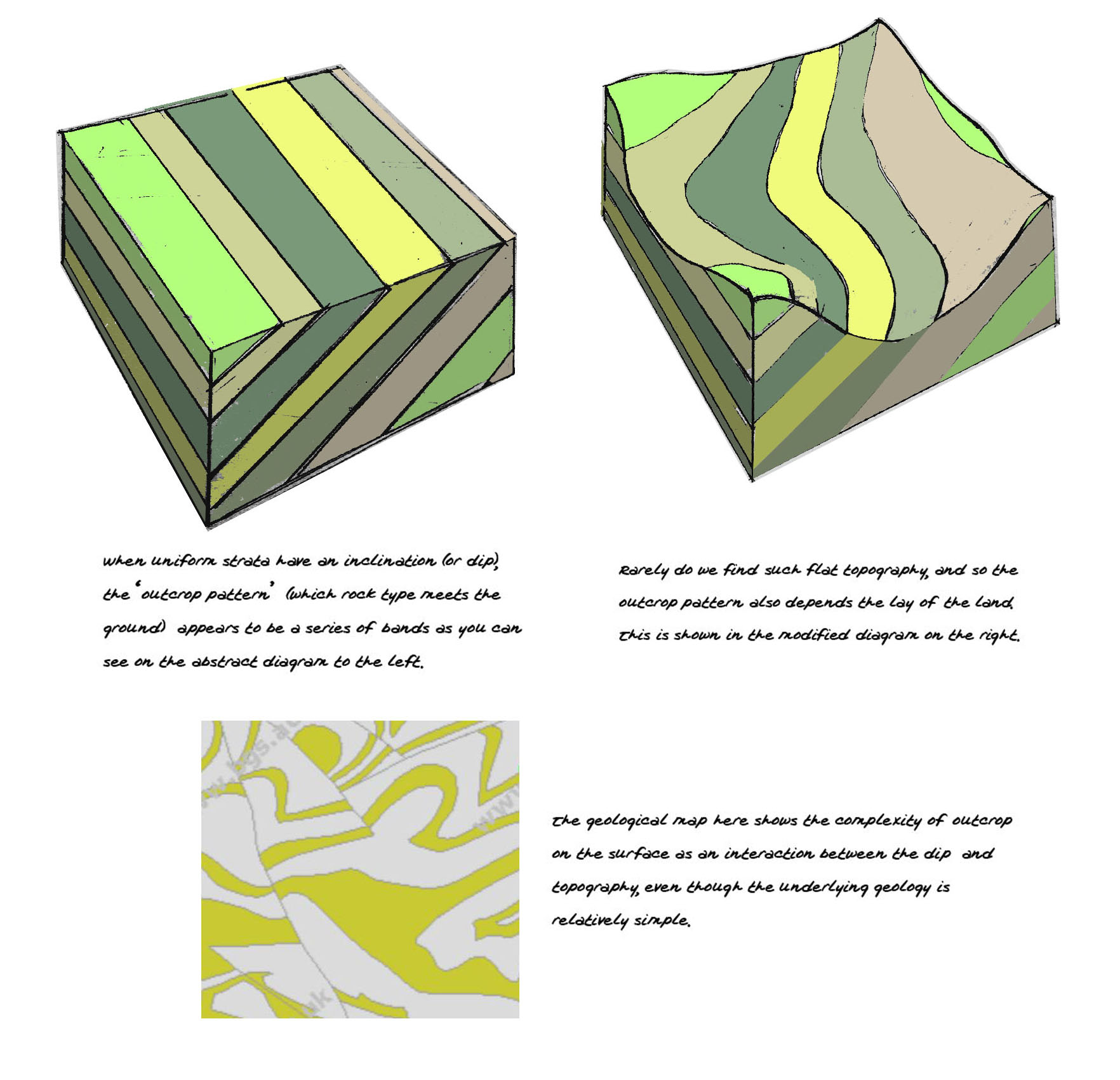
Dip, or inclination is an important aspect of geology, that determines which rocks can be found at the surface:
Continue onwards past the large quarry that extracts building stone from the Lepton Edge Rock, up to the folly to see the panoramic view. If you were to look eastwards 17,000 years ago during the last ice age, you would be able to see a glacier dominating the landscape that came as far as Ossett before retreating. The low lying areas in the Calder valley to the North would be filled with wide rivers carrying meltwater from these glaciers as the climate began to warm. In fact, igneous rock can be found in the gravel pits of this basin, that has been identified as derived from the Lake District.
You will eventually ascend back up to the heights of the Birstall Rock of Grange Moor, which you may recognise from the resilient landscape it has influenced. As you walk towards Lilly Lane, you should notice an old quarry on the side of the Birstall Rock ridge to the left. You can see how thebeddinghere is thick, and has been resilient to weathering, shown by the rounded smooth nature of the rock surface.